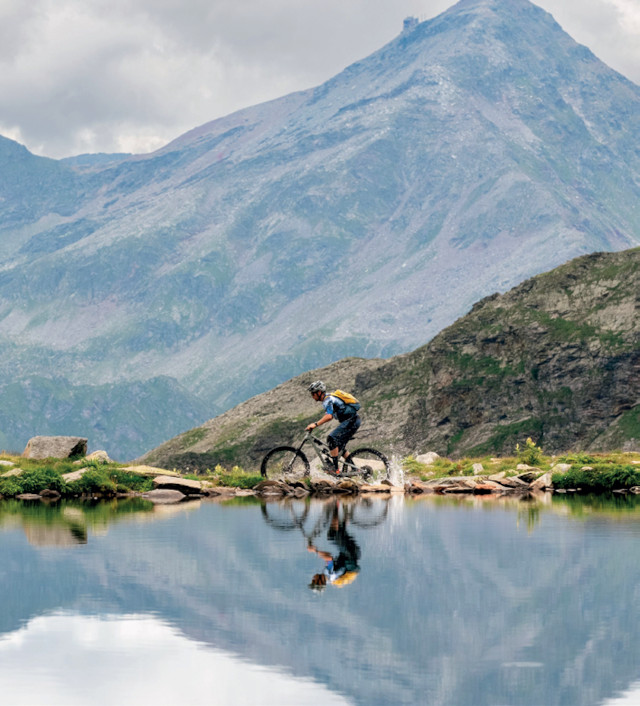
Not the first time in ValchiavennaVacanze we are affording space to the Pian dei Cavalli and the way up to Lago Bianco. Indeed the path heading off from Campodolcino to the natural basin is one of the most popular routes for cyclists (mtb and e-bike) during the summer. It starts in the centre of the village (1,070 metres) and you arrive lakeside at an altitude of 2,323 metres, after a a ride of about 16 kilometres, half of which you cover on tarmac. But let&´s make it clear from the outset: this is a demanding route. Hence, before clambering aboard your two-wheeler there are a few things to bear in mind; these are summarised below with the help of two genuine experts in the field - Adam Quadroni and Stefano Tam.
Drinking water.
Having left Campodolcino (1070 mt.) you’ll find numerous fountains along the way. The last one is at Alpe Toiana just above San Sisto. There are also streams and rivers but it’s better to carry with you supplies for the entire trip.
Never trust the weather.
We are in the mountains and it can happen that even the most reliable of forecasts can turn out to e wrong. The route towards Lago Bianco takes in an environment somewhat exposed to alpine fluctuations. It’s important to set out early in the morning to have the whole day before
you in order to manage any unexpected weather eventualities. It’s also advisable to have rain gear and clothing with long and short sleeves with you
No mechanical support.
If anything happens along the route you’ll have to improvise; the only point of assistance is at Campodolcino, the point of departure, at the bike rental outlets. Hence it’s important to have everything with you necessary for minor repairs, including punctures.
It’s not a gravel route.
The route to Lago Bianco is an MTB route with regular technical points and rocky, graveled sections. Fat tyres and shock absorbers are advisable. And don’t hesitate if at some stage you feel like getting off and pushing for a short while.
Recharging batteries.
The itinerary has inevitably been wellbeaten by many on pedal-assistedmodels. However once you’ve departed from Campodolcino there are no available charging points so use your e-bike input sparingly.
Pay attention to the signposting.
There are markers along the route but some of them take some finding! On the whole the way is well signposted but once you reach the Pian Dei Cavalli do pay attention to the red-white-red stripes daubed on the rocks. You can of course follow the GPS track on your computer.
The phone will connect.
The climb to Lago Bianco is an intense enough experience and should be tackled with care. Of course as the itinerary takes place at altitude it’s reassuring that the entire route is
served by a telephone signal. Good news for managing emergencies. However, given the context and situation, we suggest you go easy on phone use whilst enjoying the fantastic panorama.
Altitude.
The highest point of the outing is Lago Bianco itself at 2,323 metres. Nevertheless for the bolder there is the chance to walk up to the passo del Baldiscio at 2,350 m.
Nest hole.
The Pian dei Cavalli area is of karstic origins. Confirmation is at hand in the Buco del Nido at 2.157 m. situated not far from the route itself. What might appear to be an ordinary rock cavity is actually the entrance to a diffuse series of tunnels up to 30 metres deep along which underground streams flow. A particularly complex system of much interest to enthusiasts of speleology.
An alternative way back.
Anyone who fancies extending the return just a little can take a detour to Isola situated about half way up to the Pian dei Cavalli. Take care because along the way the signposting blends in with the surrounding environment.